Wednesday, June 18, 2014

Aotearoa...South Island Tour: Tour Map

Forgot to post this map the other day showing our route around the South Island of New Zealand.


Thursday, June 12, 2014

Aotearoa...South Island Tour: Part III

I was sitting in a bar in Auckland one night and met a fellow traveler from Germany.  We were talking when it came up that we both were interested in doing a South Island campervan tour.  As it was too loud in the bar to discuss this topic, we exchanged phone numbers and made plans to meet the next day over coffee to discuss our plans.


Me and Peter-Alexander on our Air New Zealand flight
from Auckland to Christchurch.
Peter-Alexander and I met the next day and discussed our plans to travel together.  After discovering that we had similar interests on the South Island and that we would probably make good travel companions, we started making plans in earnest.  I bought my airline tickets (had to fly from Auckland to Christchurch), rented the campervan and started looking through my New Zealand Lonely Planet. On February 23rd, Peter and I flew out of Auckland on our way to the South Island.  The short flight took us over the Tasman Sea, Marlborough Sound, the Southern Alps and into Christchurch.  On the way, I got to see the top of Mount Taranaki, above the clouds while cruising at 30, 000 feet.  Having missed this sight on my North Island tour, I immediately began thinking about how I might be able to Photoshop the pics together to get a whole view of the mountain.  Not going to happen. HA!


One of the many ruined buildings in the Christchurch
central business district.
We landed in Christchurch in the early afternoon, took a taxi to our hotel, and headed out to lunch.  After lunch we walked around Christchurch.  In September 2010, Christchurch was hit by a 7.1 magnitude earthquake that devastated the community.  Significant aftershocks struck the already ruined city in February and June 2011.  Walking around the CBD (central business district), signs of the devastation were still evident. Buildings were in ruin, whole areas of the downtown were cordoned off, and debris piles were seen everywhere.  We ended up visiting an earthquake museum and after walking through the museum and reading all of the information provided, I literally welled up in tears.  The plight of the residents was truly moving.  On the other hand, the tenacity of the residents to rebuild was evident and strong.  To this day, Christchurch continues to experience smaller aftershocks and heavy rains often produce severe flooding due to the instability of the outlying land around the city.  If you ever visit Christchurch, take a moment to look at the devastation and experience the unbelievable sense of community as the city marches on in its attempts to rebuild.


Peter-Alexander in the campervan...such luxury!
The next day we picked up our campervan.  Wow was that thing big!  A 7 meter, fully loaded Mercedes complete with stove, microwave, refrigerator, sink, pressurized hot and cold water, a toilet and shower...what a beast!  We first drove to a grocery store and bought our initial provisions and then headed to a campervan park just outside of town.  The next morning we headed to our first destination, a small town called Akaroa on the Banks Peninsula.  The drive out to Akaroa was stunning; winding roads through bucolic countryside, sheep everywhere, blue skies dipping down to the ocean and some kind of gran prix race going on which resulted in a detour.  Oh well, can't plan everything out and besides it took us past a french cheese shop where we stopped and bought some amazing cheese.  Little did we know that cheese shopping would become an recurring activity on this trip.


View from the rim of the inactive volcano overlooking Akaroa.

Sunset over the Banks Peninsula.
Akaroa is a cute, French community on the flanks of an inactive volcanic cone that forms the bulk of the Banks Peninsula.  The drive to Akaroa starts at the crater's edge and then slowly descends to the shoreline.  From the top we were afforded expansive views of the peninsula, the numerous small bays and islands that dot the coastline, and the vast expanse of the South Pacific Ocean.  We reached town and found our camp site which was located on a bluff overlooking Akaroa Harbour and a short walk through a forest to town. We went into town, had lunch and explored this decidedly French village.  That night, Peter-Alexander and I dragged out our camp chairs, opened a bottle of French red wine and watched the sun set over the peninsula.  What a great start to our adventure.


Lake Tekapo and the Southern Alps.
The next morning we headed out to Lake Tekapo which is on the eastern flank of the Southern Alps.  We were truly amazed upon arriving at our campsite to see the gorgeous view of the lake, with its aquamarine and turquoise glacial waters, backed by verdant green hills.  In the distance you could catch a glimpse of the higher peaks of the Southern Alps.  It started to mist so we decided to go to the hot springs located a couple hundred meters from our campsite.  While this hot springs was actually a tourist destination, and I would not have typically gone there due to the vast number of families with children (luckily they had an "adults only" pool), it worked out well as the mist changed to rain, then a downpour.  We soaked for a couple of hours then hit the sauna and steam rooms.  Feeling quite relaxed, we headed back to the campervan and cooked duck confit and risotto with a bottle of pinot noir for dinner.  Ahh, bliss.


Another view of Lake Tekapo.
Due to the rains the night before, when we woke the next morning we noticed that there was snow on the hills by the lake.  The scene was beautiful with the snowcapped hills reflected in the still blue waters of Lake Tekapo.  The rains stopped so we embarked on a hike up Mount John which has an observatory at the peak. The hike itself was moderate in difficulty, not so much steep as long, but the views from the summit were worth it.  After a latte and picture taking, we started back down the mountain, hungry and a little tired.


Aoraki (Mount Cook) as seen from our campervan.
From Lake Tekapo we next headed to Aoraki or Mount Cook.  Aoraki is 12,218 feet high and is one of the most beautiful mountains I have ever seen.  Glaciers cover the summit and sister peaks surround this stunning mountain.  We stayed at the White Horse Hill National Park campsite and when we got to our assigned site and stepped out of the campervan we were treated to a phenomenal view of Aoraki...it was right there!  If felt like we were literally sitting at the base and looking up at the peak.  I immediately took out my camp chair and just plopped myself facing the mountain and reveled in the unsurpassed view.  As we were a little sore from the trek up Mount John the previous day, Peter-Alexander and I decided to just relax and enjoy the view rather than embark on another hike.  Watching the sun set behind the ridge of the surrounding mountains was mesmerizing as the white glaciers turned from orange to red and finally purple.  The South Island was definitely living up to its reputation for being one of the most beautiful places on Earth.


Eunice and Francois at Aoraki.
The next morning as we were finishing breakfast and getting ready to leave, I was sitting with my coffee just chilling with my personal view of Aoraki when a familiar face walked by.  Perplexed, I called out, "Francois?  Francois!  Bonjour mon ami!"  I had first met Francois in Mexico and he helped me teach French to the cruisers who were making the jump from Mexico to French Polynesia.  He and his girlfriend, Eunice, were camping a mere hundred feet away from us.  We invited them over to our "luxurious camper" and spent about an hour looking at the South Island map and getting their take on places that we shouldn't miss.  We bid "au revoir" and headed out to the town of Oamaru, a midway point between Aoraki and our next planned destination of Dunedin.


I love the Moeraki Boulders!  These guys would make
great lawn decorations.  LOL!
On our way out of Oamaru, we stopped at the waterfront which has numerous historical stone buildings dating back over a century.  We strolled the streets and visited the numerous shops and cafes along Waterford Road.  Then we headed to the Moeraki Boulders.  These rocks along the shore are amazing in that they are pretty much perfectly round and smooth.  After clambering around the rocks, we got back in the campervan and headed to Dunedin where we had plans to meet up with a gal we had met back in Auckland.


Pints with Hannah at a local university pub.
Hannah is a PhD candidate that we met in a bar in Auckland one night.  She attends a local university in Dunedin (one of the largest in New Zealand, in fact, Dunedin is a huge college town).  We also went to a concert with her in Auckland to see MoZo. Amie and Mo are from Seattle and when they found out that I was from Seattle, they invited me to their concert the next night (we also met them in a bar in Auckland).  These girls were on what they called a "bike tour" of New Zealand and Australia, performing all along the way. Shout out to MoZo for being the coolest (can't wait to see them when I return to the Pacific Northwest!).  We met up with Hannah for happy hour which turned into dinner and more happy hour.  


The Dunedin Railway Station.
The next day, Peter-Alexander and I set out to explore Dunedin.  Dunedin is not only home to the original Cadbury Chocolate Factory (purchased tons of chocolate here), it also has the most photographed building in the Southern Hemisphere, the Dunedin Railway Station which opened in 1904 and was a central focal point for connecting Dunedin to the industrial centers of Christchurch and Invercargill.  It is built in the Flemish Renaissance style and is truly a masterpiece of architecture.  I can see why it is touted as the most photographed building in the Southern Hemisphere.


Milford Sound (photo courtesy of PAB).
After two days in Dunedin, we headed north to Milford Sound. My travel companion, Peter-Alexander, had made arrangements to do a dive there, having recently received his scuba diving certificate in Fiji, and was anxious to dive what is claimed to be one of the ten best dive spots in the world.  Milford Sound is absolutely stunning and reminds me of the mountain backed fiords and inlets found on the northern coast of British Columbia in Canada.  Due to the timing of his dive and the distance to our next destination, Queenstown, I only stayed in Milford Sound for a short time because I had to drive solo to Queenstown.  I did, however stay long enough to have what ended up being the best pepper steak pie I ate in New Zealand at a place called the Blule Duck Cafe. Peter-Alexander's dive company provided his transport to Queenstown as part of his package.  The drive took me through the mountains surrounding the sound and then south back to Te Anau, where we had spent one night before heading to Milford Sound, and then northeast to Queenstown.  The road into Queenstown is flanked by beautiful lakes and mountains and it takes a lot of energy to stay focused on the winding mountain roads with such amazing scenery all around you.


Malll Street pedestrian block is filled with
shops and cafes
When I arrived in Queenstown, I located our campervan park and got settled in by hooking up the electricity, filling the water tank and doing some light cleaning.  Then I set out my camper chair and just took in the sights from my chair.  I know, lazy, but after the four hour drive, I was beat!  Peter-Alexander got back later that day and recounted all the details of his dive.  I could tell he was excited and we talked about what he saw well past dinner.  The next day we walked around town, had lunch and did some shopping, stopping by the waterfront which is the hub of all the adrenaline activities that Queenstown is known for in New Zealand.


The Franz Josef Glacier (it's the part behind the lone
lone tree just left of center).
The next day we took off early as we had a particularly long day ahead of us.  We left Queenstown and headed to Wanaka, a lakeside town out of a postcard.  With a lake bordered by mountains, a waterfront promenade and cafes and shops everywhere, we parked the campervan and headed to a cafe for breakfast where I had a delicious steak and mushroom pie (have you noticed my obsession with pies?  LOL!).  We spent a couple of hours in Wanaka and then headed north towards the Franz Josef Glacier.  We both admitted that the pictures in the brochures were definitely taken before global warming reached its nasty tentacles down to melt vast fields of ice off of this glacier.  In less than twenty years, this glacier has receded hundreds of meters.  If you don't believe in global warming you might just want to leave my blog as I probably have very little patience to put up with your ignorance regarding the SCIENTIFIC proof of this disaster.  Okay, I'll step down from my soapbox now.


Sunset at Hokitika on the West Coast of South Island.
From the glacier, we made our way to the town of Hokitika, a waypoint as we made our way further north to the Abel Tasman National Park.  We had wanted to get a campsite in Takaka  which was close to the national park, but did not realize that it was a national holiday and schools were out so the campervan parks were all full.  We ended up in Motueka, which was just far enough south of the national park that it was not convenient for us to do any of the activities we had planned like sea kayaking and hiking.  Oh well, you can't do everything and we did end up in a really nice campervan park so we didn't sweat it.


The vineyard at Milcrest Estate in the Marlborough
wine region.
Our next destination was Nelson.  Nelson sits in the Marlborough wine producing area of the South Island and is famous for its sauvignon blancs.  We got a campervan site that was very close to the town center and booked a wine tasting tour for the next day. Our tour guide picked us up early the next morning and after we had collected the other passengers, we headed out to the vineyards.  Our tour took us to four vineyards, and while I'm usually not a big fan of whites (aren't they really light? like a breakfast wine?), we did taste a couple of decent sauvs.  It was only later when we reached our last vineyard, a tiny operation situated on a hill overlooking Tasman Bay, that I got to savor a young pinot noir that took me by surprise. Delicious!  


These guys will end up in a Pinot Noir.  Yum!
At all of the wine tastings, we got to walk through the vineyards and see the actual grapes and learned much about the production of wine.  The entire time we were walking around, the scene from an old black and white "I Love Lucy" episode kept running through my head.  You know the one, where Lucy and Ethel are stomping grapes in a barrel, end up fighting and flinging squashed grapes at each other?  Hilarious!  From first presses to ice wines, we sampled our way through the Marlborough wines.  We stopped at the second vineyard and had lunch outdoors under a huge shade tree.  The food was amazing and the group had a chance to converse and tell a little about themselves as we ate lunch and sipped wine.  In the end I only tossed one glass (a sangiovese that had very prominent licorice tones...I HATE black licorice and anything that remotely resembles that awful taste!).  By then end of the tour I was quite relaxed and ready to get back to our campervan for dinner.


The Free House in Nelson...so many choices!
Back in Nelson, I found a great craft beer place called the Free House that had an awesome selection of beer including several IPAs (my fav), a handful of Pale Ales and assorted other styles.  The converted church had a great outdoor seating area in the back and the weather was perfect for just ordering a pint or two and sitting on one of the many couches placed under shade trees or canopies and letting the day pass by under the soothing effects of the hops.  I chatted up some locals who told me that this was the best place for craft beer in Nelson.  Well, my beer radar must have been working because I found it and got to engage in one of my favorite past times.


The coastline outside of Kaikoura.
Kaikoura was our next stop and was only about 240 kilometers away.  I had wanted to surf here but the weather did not cooperate as it rained most of the time we were there.  So I had a lobster dinner instead and enjoyed that, along with a couple of pies during that stop, almost as much as I would have enjoyed hanging ten. When we left a few days later, as we were driving the coastal route, my eagle eyes spotted some little blue penguins on the beach.  What a rare and wonderful sight that was to see the little guys waddling on the beach!


Abel Tasman National Park as seen from the plane
on our return trip to Auckland.
After cleaning out the campervan and returning it to the rental facility, we headed back to the same hotel that we stayed in when we first arrived in Christchurch at the beginning of the trip.  Our flight back to Auckland the next day wasn't until late morning so we were able to have breakfast at a leisurely pace before heading to the airport.  Peter-Alexander was picking up a camper van in Auckland and starting his North Island tour for a couple of weeks.  Me?  I was going back to my apartment to relax after a 3064 kilometer (1903 miles) road trip through one of the most stunningly beautiful places I have ever been fortunate enough to visit.

Stay tuned for the next installment...Australia!  And enjoy these other photos from my South Island tour.


Christchurch: Tribute to its reconstruction.
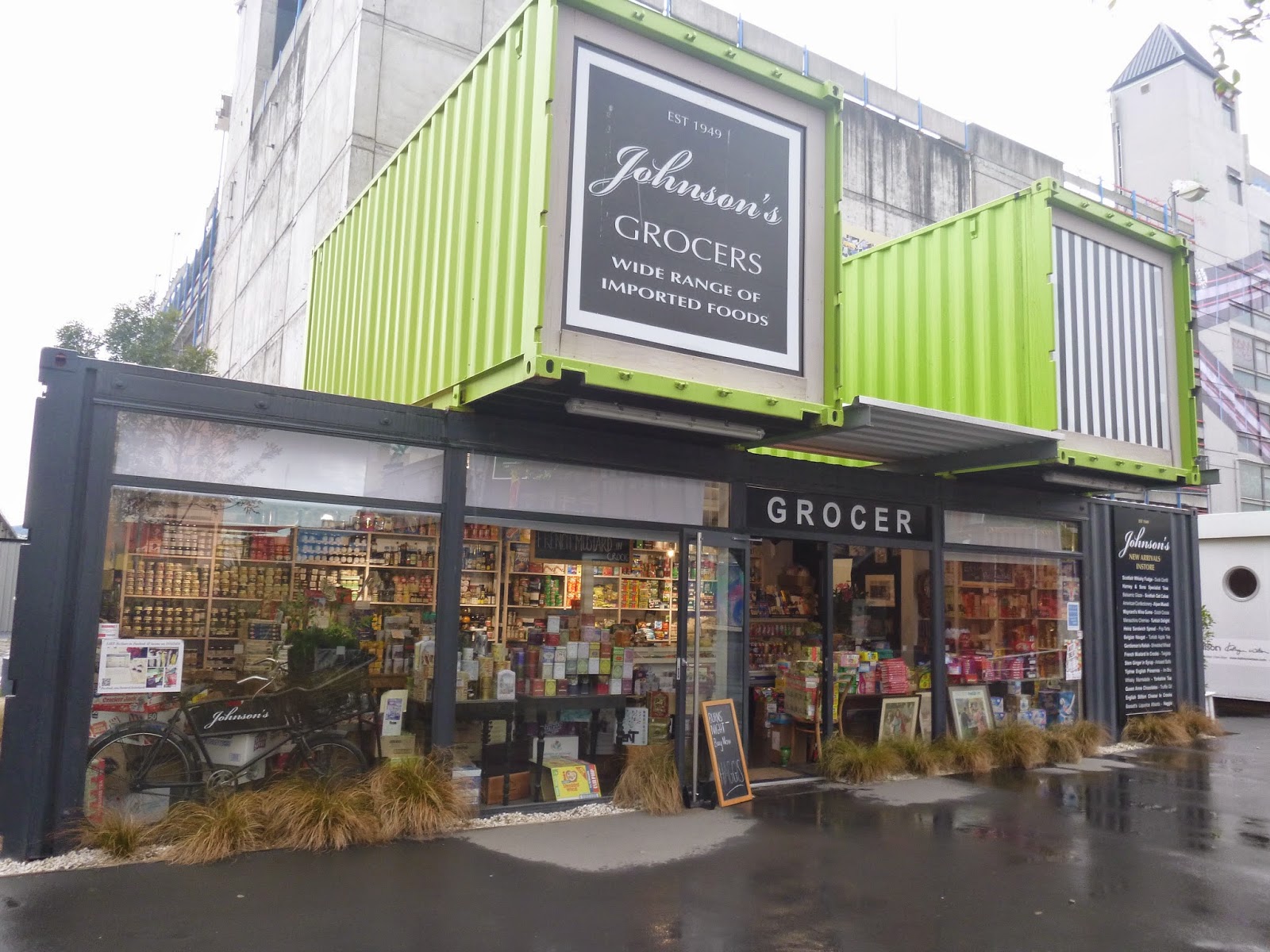
After the earthquake and the toppling of many buildings
in the CBD, businesses moved into containers that were
grouped together and stacked right outside of the CBD.
Akaroa scene.
Lake Tekapo: Selfie with Peter-Alexander.
Mount John: The observatory at the peak.
On the way to Aoraki.
Aoraki: White Horse Hill National Park.
Our luxurious campervan with Aoraki in background.
Aoraki: Peter-Alexander greets our morning visitors.  
Hmm?  Do we have any duck confit left?  If not...
Oamaru: Waterford Road shops and cafes.
Oamaru scene.
Dunedin: Court House.
Dunedin: Pouring myself a schooner at Speight's Brewery.
I think I see a career change in my future.
Otago Peninsula: Baby penguins at the Penguin Place Hospital.
Mirror Lake.
Cascade Creek campsite.
Erlington River hike.
Waiho River swing bridge at Franz Josef Glacier.
Franz Josef Glacier: Sometimes I get so excited
that I just jump up and down.  Don't you?
Lake Wanaka.
Nelson: Free House Tap House.
Nelson: HOPS!
Nelson: The perfect snack!

Sunday, June 8, 2014

Aotearoa...North Island Tour: Part II

Connolly and our campervan;
home for the next ten days.
In early December, my friend Connolly (from s/v Sea Monkey) called me up and asked if I would be interested in doing a campervan tour of the North Island of New Zealand. Always ready for the next adventure, I immediately said, "Hell ya!" and the next thing I knew I was packing my backpack and getting ready to hit the road.  Connolly had met up with Hannah (from s/v Cashtoki) and her boyfriend, Daniel, up in Whangarei and then drove down to Auckland in their Wicked campervan on their way to the airport to pick up Hannah's sister, Esther. Hannah and Daniel dropped Connolly and me off at the Wicked campervan office and we picked up our campervan with plans to meet somewhere on the Coromandel Penninsula later on in the day.  Our campervan was named "Radio Birdman"; each campervan is different, usually with a musically-themed graffiti paint job and somewhat snarky saying spray painted on the back.  Once we got possession of our van we headed out armed with our GPS and hit the road.


Your driver for the next ten days.
Our first stop was in Thames, a small town at the southern end of the Firth of Thames. We ended up having lunch there and waited for Hannah, Daniel and Esther to arrive, having called them to let them know where we were.  Once the two camper vans were together, we headed north up the Coromandel Penninsula to the town of Coromandel where we spent our first night. Route 25 took us north and the views looking across the Firth of Thames towards the main part of the North Island were stunning.  But there was little time to enjoy the views as the road was quite narrow and extremely curvy.  And don't forget, for us Norte Americanos, I was sitting in the passenger seat (behind the steering wheel) and driving on the "wrong" side of the road!  While this wasn't my first time on the wrong side of the road, it was my first time driving from the passenger side.  We parked our vans and made a pot luck that night and just hung out watching the sun set over the North Island. Relaxed bliss!

Our Scottish friends and us enjoying a soak
at Hot Water Beach.
The next morning we woke up to a $200 fine for parking our campervans in what was apparently an unauthorized area.  The weird thing about it was that right behind our campervan was a "No Freedom Camping" sign.  Not being from New Zealand, I really didn't pay much attention to the sign as I didn't know exactly what it meant.  Oh well, live and learn.  
After breakfast we headed out to Whitianga and what is known as the "Hot Water Beach". Here's the deal...You head out to the beach on an outgoing tide and rent a shovel, dig a hole and watch hot water bubble up into your "pool".  It's like having your very own hot tub on the beach. The day we went it was a little overcast but that was fine for us as the hot water pools were the perfect temperature for just hanging out with a few beers on the beach.  You have to get there early as all the good spots get taken quickly.  If you are too close to the thermal springs, the water will be so hot that you cannot get in; too far from the source and your pool gets flooded by the ocean waves and its too cold.  A young Scottish couple on holiday invited us to join them in their pool (which they had recently acquired as it was abandoned) and the seven of us enjoyed a relaxing time soaking in our hot tub.


The campervan gang at Wai-O-Tapu.
Early the next morning after breakfast we headed to our next destination, Rotorua, home of the famous hot springs and Hobbitville (which is actually in Matamata). While we didn't visit the set for the famous movies, we did make our way to Wai-O-Tapu ("Sacred Waters") and to what the locals call "Hot and Cold Springs".  This is a roadside stream, actually two streams; one is cool water and the other comes from a geothermal spring and is hot.  The streams are pretty shallow and, conveniently, there are flat rocks set in the hot spring stream to sit on while lounging in the hot springs. When you get too warm you just venture into the cooler waters of the cold spring.  We met some young German backpackers and hung out with them, partying late into the night drinking beers in the thermal waters.  Many locals come to this free thermal area and so we also got to hang out with them. Something about a hot spring, beer and light rain seems to loosen everyone up and a good time was had by all.


A campfire, extended happy hour and
 friends...does it get any better than this?
We continued south into another national park and found a sweet campsite.  Even though it was raining a little, we were still able to find some dry firewood.  We tossed the frisbee around for a bit in the afternoon and when the rain started, well, we started our happy hour. As on other nights, we put together a pot luck between the two vans and feasted.  We usually back our campervans up back to back and pop the hatches.  This creates a large awning under which we set out our camping stoves and tables and prep and eat dinner. This system seemed to work out pretty well for us during the rainy days of our trip.  After dinner we sat around the campfire.  Esther proved to be an expert fire tender and with Daniel on the guitar, Connolly trying his hand on the harmonica, and happy hour still going, we sat back and chillaxed (chilled + relaxed = chillaxed) into the night. The days were warm at this point but when the sun went down, so did the temperature.  Besides, who doesn't like a campfire to pass the night away?

Daniel, Esther, me and Connolly;
Tongariro National Park.
Our next stop was Mount Ngauruhoe a little bit south of the southern shores of Lake Taupo.  We first stopped in Taupo to reprovision and check emails. Unfortunately, it was cloudy and rainy as this road is part of the Volcanic Scenic Highway.  Needless to say, we did not see the volcanoes, but the views of this immense lake were spectacular!  Further south, we entered the Tongariro National Park, with Mount Ngauruhoe in the distance. Mount Ngauruhoe was used as Mount Doom in the Lord of the Rings movies.  When we were there, during the southern hemisphere summer, the mountain had a hefty amount of snow covering its peak.  We found a national park camp site and then went on a short trek to a waterfall (which incidentally was also used in the LOTR movies).  The drizzle continued, so we headed back to the campervans, made dinner and then played silly drinking games.  I lost...enough said about that!  HA!

This is where the two campervans separated as Hannah, Daniel and Esther needed to get back to Auckland to catch a flight back to Perth, Australia.  We had breakfast, said goodbye, and Connolly and I headed south to Wellington.


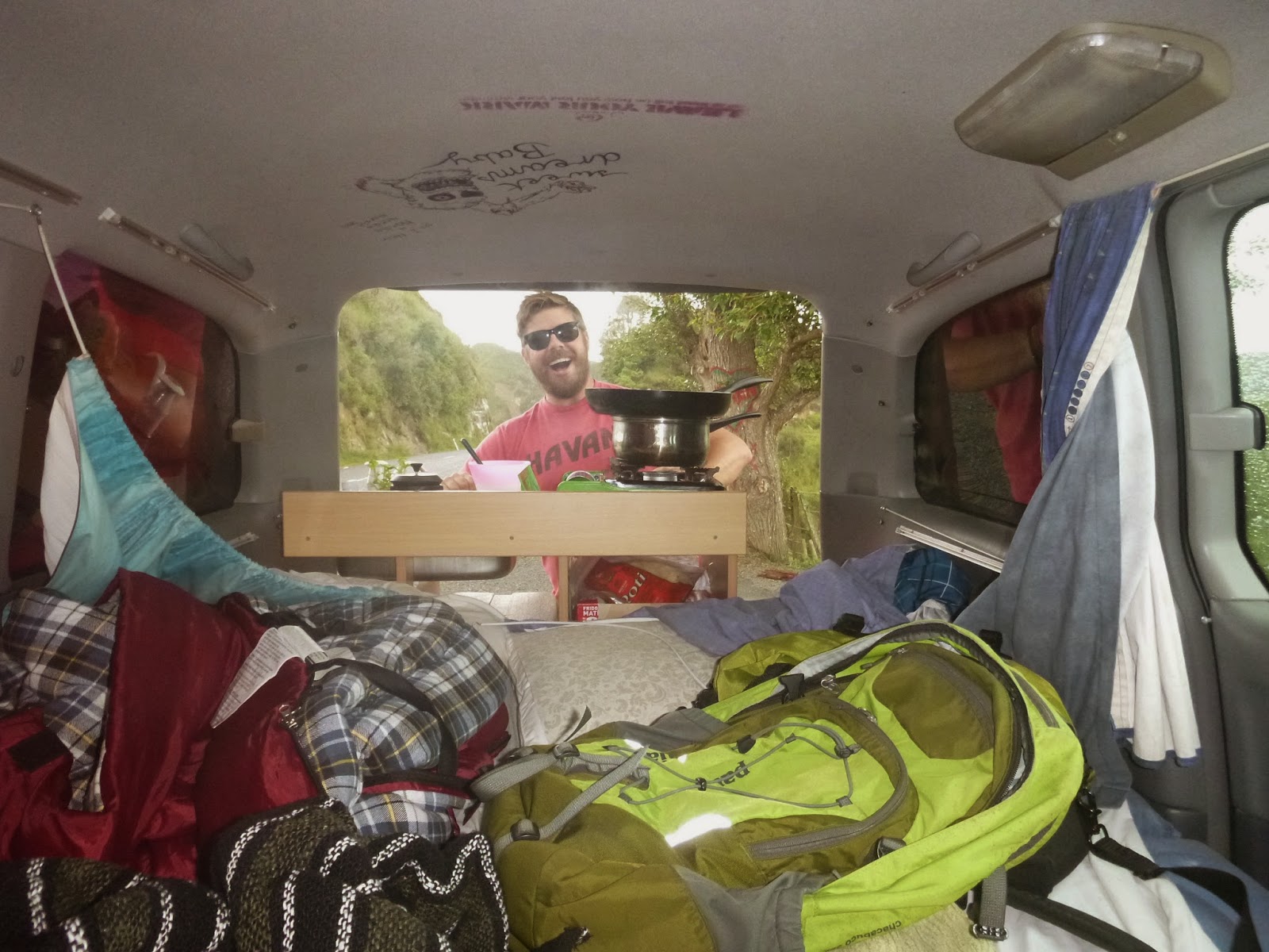
Helluva weekend in Wellington!  No pics so here's a
random shot of Connolly prepping a meal in the van.
As we approached Wellington, Connolly checked our guidebooks looking for campervan sites. The prospects were slim, so we pulled into the Te Papa Tongarewa Museun parking lot (called "car parks" in New Zealand) and decided to check out the museum.  The museum is free and is part of the New Zealand National Museums system. Inside, we viewed amazing artifacts from the Maori culture dating back centuries, as well as exhibits depicting the flora and fauna of the area, and a small exhibit dedicated to the devastating earthquakes that rocked Christchurch on the South Island (more about that in another blog post).  On our way out of the museum, Connolly checked with the car park attendant and we found out that we could camp overnight in the car park for a lot less money than any of the other campervan sites we had located so decided to pay the fee and hang out there.  This worked out well for several reasons: (1) The car park was centrally located to downtown (called "Central Business District" or "CBD" in New Zealand); (2) there was a grocery store and liquor store a mere 3 blocks away; (3) there was also a farmers market nearby; (4) a Starbucks four blocks away (with free wifi); and, (5) it was the weekend. As it was the weekend, Connolly and I decided to check out the Welly nightlife and made our way to a number of bars and clubs; knowing that our "home" was only a few blocks away. Nice.


Our campervan, Connolly and Mount Taranaki.
There is so much more to the mountain that
was obscured by cloud cover.
From Wellington, Connolly and I headed north to New Plymouth which sits on the north side of a small piece of land that juts out into the Tasman Sea.  The bulk of the peninsula is taken up by the Egmont National Park and the centerpiece of this park is Mount Taranaki.  Again, cloudy weather prevented us from seeing the peak of this mountain but we were able to drive our campervan pretty high up the mountain where we trekked a short hike.  The views from the mountain opened up to vast flat plains that skirted from the sea to the base of Mount Taranaki. Once we were done up on the mountain, we drove to the town of New Plymouth, found a seaside campervan park and took out our camping chairs, faced the sea and just chilled with some beers, watching the waves crash on the rocky coastline and the gulls pierce the sky in search of fish.


River along the Forgotten World Highway.
Okay, so the next day we decided to take the "Forgotten World Highway" north on our way to Raglan, a surfing community on the west side of the North Island.  THIS WAS A HUGE MISTAKE!  So the brochures depict a winding road through lush semi-tropical forests, with exotic trees, a gorge, and a meandering river. Sounds great, right? What the brochures don't mention is that it takes about 4 hours to complete the 43 kilometer route, that a vast majority of this route is unpaved, and that after the first 45 minutes or so, the scenery just repeats itself to the point, as the driver, I just wanted out! Driving 10 kilometers an hour (about 6 miles per hour!) at times, trying to avoid potholes that could swallow the campervan, and all the while being vigilant to the thought that sheep could leap out of the sides of the road at any minute (this happened several times on this trip), is not my idea of a fun, relaxing drive through the country. We finally left the FWH behind us, made our way through Hamilton, stopped for gas and headed west to Raglan.  And not a minute too soon.


Surf Beach at Whale Bay.  Watch out for the rocks!
The campervan park in Raglan is situated across the bay on a sandy stretch of land just west of the town center.  It is connected by a footbridge that makes the trek into town a simple 10 minute stroll.  The campervan park was quiet and clean and had full amenities (showers, cooking and laundry areas, etc.) and its location just outside of the center of town made it one of our favorite spots.  We explored the three surf beaches at Whale Bay and looked west out across the vast expanse of the Tasman Sea, imagining that Australia was just beyond the horizon (okay, not so much just beyond the horizon, more like a thousand miles or so). We found a quaint hotel that had a great porch bar and sat down for some sundowners and dinner, people watching while the sun went down over Raglan.


10 days, 2 dudes, you gotta expect a bit of a mess!
The next morning we got up early, cleaned the campervan and headed north towards Auckland.  We arrived at the Westhaven Marina, unloaded the campervan, then drove it back to the Wicked lot.  The deal with Wicked Campervans is that when you return the vehicle if you pose naked in front of your van for them to snap a photo, then they discount your rental by a day or two.  I was fully prepared to take advantage of this discount; Connolly wasn't as on board as I was.  In the end, I got the discount, but didn't have to strip down.  I refuse to ponder why I wasn't asked to get naked.

Here's a map of the route we took (approximate) and some additional pics taken along the way.  Stay tuned for Part III: South Island Tour.


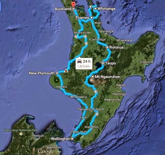
Approximate map of North Island Tour route.  Started in Auckland
and ended in Auckland.  I know the little tag says 1815 kilometers,
but in reality we clocked about 2000 kilometers.
View from our first campsite on Coromandel Peninsula.
Sun setting on the Coromandel Penisula.
We wondered about how offensive this might be to blind people.
Then we thought about it.  Still felt a bit weird.
North Island countryside.  Yes, that's our road down there.
Connolly testing the law.
Me and Connolly at Hot Water Beach.
Daniel and Hannah, roadside brekkie at Wai-O-Tapu.
Esther, Daniel, and Hannah inside their campervan.
This was silly drinking game night.  It involved dice
and lots of booze.  That's all I remember.
The waterfall in Tongariro National Park that was used in
one of the Lord of the Rings movies.
Connolly on the harmonica.  Dylan he is not.
But kudos for a valiant effort!